


Essential Planning: Before You Hit the Trail
Proper planning is the key to a successful and enjoyable trek. Here’s what every nomad needs to know before lacing up their boots.
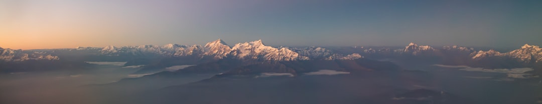
Key Trek Statistics
Total Distance: ~260 km (161 miles)
Typical Duration: 15 days
Highest Point: Thorong La Pass at 5,400m (17,716 ft)
Total Ascent: 11,685 meters
Total Descent: 11,358 meters
Average Daily Cost: US$30-35 per person (NPR 4000-5000)
Accommodation: Guesthouses (teahouses) along the route.
Permits & Compulsory Guide (2025 Update)
As of April 2023, Nepal's tourism regulations have changed significantly. Here's the deal:
Guide is Mandatory: All international trekkers are now required to hire a licensed Nepali guide for the Annapurna Circuit and other major routes. Solo trekking is no longer permitted. You can arrange this in Kathmandu or Pokhara, or through a reputable trekking agency beforehand.
Permits Required: You will need two permits: the Trekkers' Information Management System (TIMS) card and the Annapurna Conservation Area Permit (ACAP). Your guide or trekking agency will typically handle the process of obtaining these for you.
Travel Insurance
Non-negotiable. Your travel insurance must cover high-altitude trekking (up to 6,000m) and emergency helicopter evacuation. Given the risks of altitude sickness, injury, and unpredictable weather, this is your most critical piece of gear. Keep digital and physical copies of your policy.
Trekking Direction: Counter-Clockwise is Key
The Annapurna Circuit must be trekked counter-clockwise. This isn't just a tradition; it's a critical safety measure. This route ensures a gradual ascent, allowing your body to properly acclimatize to the increasing altitude before tackling the high point of Thorong La Pass. Attempting it clockwise leads to a dangerously rapid ascent, dramatically increasing the risk of severe altitude sickness.
The 15-Day Annapurna Circuit Itinerary
Day 1: Bhulbhule to Ghermu
Distance: 15 km / 9 mi
Time: ~4 hours
Ascent/Descent: +663m / -324m
The Experience: Your trek begins! Starting from Bhulbhule avoids the dustier sections of Besi Sahar. The first day is a gentle introduction, walking through lush rice terraces and forests alongside the roaring Marsyangdi River. The main challenge is the heat, but the views of small waterfalls and the impressive Syange waterfall make it all worthwhile.
Day 2: Ghermu to Tal
Distance: 18 km / 11 mi
Time: ~5.5 hours
Ascent/Descent: +1291m / -807m (via footpath)
The Experience: Today offers a choice: a challenging but scenic footpath or an easier road walk. The footpath is a true hiker's delight, with steep sections rewarded by incredible views, large waterfalls, and thrilling suspension bridges. You'll end in the beautiful village of Tal, which sits in a wide, flat valley that was once a lake.
Day 3: Tal to Timang
Distance: 21 km / 13 mi
Time: ~4.75 hours
Ascent/Descent: +1297m / -376m
The Experience: The landscape begins to change as you gain elevation. The trail from Tal to Dharapani (where you'll have a permit check) is stunning. After that, much of the day is on the road, but the destination is worth it. Timang offers your first truly spectacular views of snow-capped Himalayan peaks, including Manaslu.
Day 4: Timang to Upper Pisang
Distance: 27 km / 16.7 mi
Time: ~5.75 hours
Ascent/Descent: +1081m / -451m
The Experience: A long but relatively easy day of walking. The scenery is breathtaking from start to finish, with snowy peaks, small glaciers, and dense pine forests dominating the view. Choose to stay in Upper Pisang over Lower Pisang—the extra 100m climb rewards you with far superior views and a more traditional village atmosphere.
Day 5: Upper Pisang to Manang
Distance: 22 km / 13.6 mi
Time: ~6.5 hours (via high route)
Ascent/Descent: +888m / -629m
The Experience: Today is one of the most visually stunning days of the trek. Opt for the high route via Ghyaru and Ngawal. It involves a very steep, tough climb, but the panoramic views of the Annapurna range are absolutely unforgettable. The trail leads you through ancient villages before descending to Braga, with its beautiful monastery, and finally to Manang.
Day 6: Acclimatization Day in Manang (3,560m)
The Experience: Rest is a weapon. This day is crucial for letting your body adapt to the altitude. Don't push it, even if you feel great. Enjoy the relative luxury of Manang—grab a real coffee, eat some yak cheese, and do your laundry. Attend the free daily talk on altitude sickness at the Manang Aid Post. If you need any last-minute gear for the pass (like microspikes or warmer gloves), this is the place to get it.
Day 7: Manang to Yak Kharka
Distance: 10 km / 6.2 mi
Time: ~3.5 hours
Ascent/Descent: +569m / -99m
The Experience: A short, slow day is the goal. From here on, the rule is to gain no more than 500m in sleeping elevation per day. The landscape becomes more barren and windswept. Vegetation thins out, and you'll likely see herds of yaks grazing. The pace is deliberately slow to aid acclimatization.
Day 8: Yak Kharka to Thorung Phedi
Distance: 8.3 km / 5 mi
Time: ~3 hours
Ascent/Descent: +565m / -92m
The Experience: Another short day brings you to the base of the pass. The altitude makes every step feel like an effort. The trail winds through a dramatic, high-altitude landscape. Thorung Phedi (which means 'foot of the hill') is the staging point for the big day tomorrow. Rest, hydrate, and eat well. Avoid the temptation to push on to High Camp unless you are feeling 100% and are perfectly acclimatized.
Day 9: The Pass! Thorung Phedi to Muktinath via Thorong La (5,400m)
Distance: 15.6 km / 9.6 mi
Time: ~6-7 hours
Ascent/Descent: +854m / -1680m
The Experience: This is it. You'll start in the pre-dawn darkness, a line of headlamps zigzagging up the incredibly steep path to High Camp. From there, it's a long, tough, but steady slog to the prayer-flag-adorned summit of Thorong La Pass. The feeling of achievement is immense. After celebrating, you face a very long, knee-jarring descent into the arid, windswept 'rain shadow' of the Himalayas, ending at the sacred pilgrimage site of Muktinath.
Day 10: Muktinath to Jomsom
Distance: 22 km / 13.6 mi
Time: ~5.5 hours
Ascent/Descent: +536m / -1396m
The Experience: The landscape is now completely different—dry, dusty, and dramatic, with colorful, eroded rock formations. Take the scenic trail through the ancient village of Lubra. The final stretch into Jomsom can be very windy and dusty, but it marks the return to a larger town with an airport and more amenities.
Day 11: Jomsom to Tukuche
Distance: 15.5 km / 9.5 mi
Time: ~4 hours
Ascent/Descent: +440m / -582m
The Experience: Many trekkers end in Jomsom, so the trail becomes much quieter from here. The path takes you past the turquoise Dhumbra Lake and through the small Tibetan settlement of Chhairo. It's a pleasant day of walking through forests and along the river, ending in the traditional village of Tukuche.
Day 12: Tukuche to Ghasa
Distance: 30 km / 18.6 mi
Time: ~7.75 hours
Ascent/Descent: +800m / -1383m
The Experience: The longest day of the trek. You'll pass the beautiful Titi Lake and traverse a stunning section of trail carved into the side of a canyon. The constant ups and downs make it demanding, but the scenery, with unique rock formations and dense forests, is a fantastic reward for your effort.
Day 13: Ghasa to Tatopani
Distance: 17 km / 10.5 mi
Time: ~4.5 hours
Ascent/Descent: +335m / -1057m
The Experience: The trail descends back into a lusher, subtropical climate. You'll pass numerous waterfalls and walk through quiet local villages. The day ends in Tatopani, which means 'hot water' in Nepali. The main attraction here is the natural hot springs—the perfect place to soak your tired muscles.
Day 14: Tatopani to Ghorepani
Distance: 17.6 km / 11 mi
Time: ~5.75 hours
Ascent/Descent: +1744m / -200m
The Experience: Prepare for a day of relentless climbing. This is one of the most physically demanding days, with a massive continuous ascent. The trail takes you up thousands of stone steps through rhododendron forests. You'll arrive in the bustling village of Ghorepani, the base for the famous Poon Hill sunrise view.
Day 15: Ghorepani to Nayapul via Poon Hill
Distance: 22 km / 13 mi
Time: ~6.5 hours (including Poon Hill)
Ascent/Descent: +622m / -2282m (total for the day)
The Experience: An early start for the 45-minute climb to Poon Hill (3,210m) to witness a spectacular sunrise over the Annapurna and Dhaulagiri mountain ranges. After returning to Ghorepani for breakfast, it's a long, mostly downhill trek to Nayapul, where your incredible journey concludes. From Nayapul, you can easily catch a bus or jeep back to the lakeside city of Pokhara to celebrate.
Accommodation Recommendations
Whether you're celebrating post-trek in Pokhara or starting your journey in Kathmandu, here are some options for every budget.
Pokhara (Lakeside)
Budget: Pokhara Youth Hostel, Gauri Shankar backpackers hostel.
Mid-range: Hotel Middle Path & Spa, Hotel Lake Shore.
Luxury: Temple Tree Resort & Spa, Glacier Hotel & Spa.
Kathmandu (Thamel)
Budget: Hotel Yala Peak, Om Tara Guest House.
Mid-range: Oasis Kathmandu Hotel, Aryatara Kathmandu Hotel.
Luxury: Fairfield by Marriott Kathmandu.


